Sunday, January 30, 2011

Byrd Park Pump House

Though neglected, one of the more interesting historic structures in Richmond is the pump house at the bottom of Byrd Park.  It claims the oddest combination of program functions I’ve ever known. 

The primary purpose of the late 19th Century building is to house water pumps powered by waterwheel.  Water was pushed uphill to the reservoir about a half mile away.  Though this pump house is no longer in use, the later pump house next door still supplies drinking water to Richmond.

The other use of the building was as a venue for dances and concerts – on the open balcony at the top floor.   From this vantage point, you could look down on the canal and locks, hear the water as it poured out of the spillway, and see across the natural beauty of the James River.  A sign at the site alludes to people arriving by canal boat to enjoy the performances.  I’m curious if that romantic scene ever occurred.  Perhaps there’s a photo of it within the archives of the Valentine Museum.

The gothic revival building was designed by the City Engineer in a gothic revival style.  It has many characteristics of a church and is highly ornate.  The windows are tall and slender with gothic arches at the top.  These features do a great job of disguising its utility. 

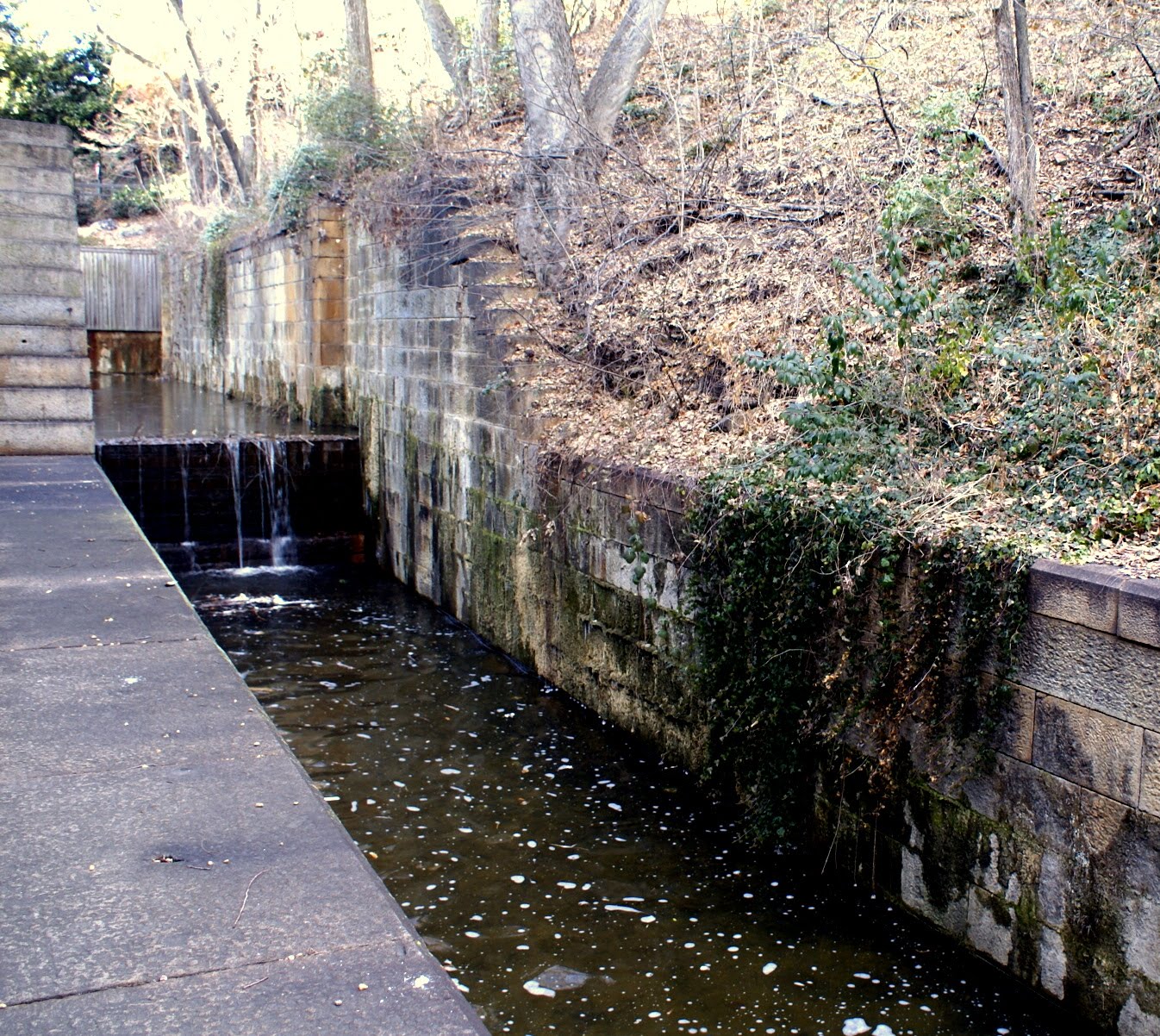
The canal locks are themselves an interesting object within the site.  There are two channels for water running parallel to the river.  Both are fed from a point up-river.  The upper one supplied water to turn the waterwheel in a sudden drop.  The lower one contains the series of locks which used to raise and lower small boat traffic around the rapids on this section of the river. 

The stonework for the locks and building is said to have come from a small stone quarry 10 yards from the front of the building.  Granite such as this was quarried at several points along the stepped falls of Richmond.  It provided an important resource for 18th and 19th Century development.   Two other quarries can be found along the western stretch of Riverside Drive near the Pony Pasture and in the center of Belle Isle.

Finding this spot is rather tricky at the moment.  There is road work being done in front along Pump House Road.  Access is blocked from the Boulevard Bridge side near the toll booth.  You now must wind your way to the west side of the Carillon and do the tricky left turn near the entrance to Kanawha Trace.  The grounds are overgrown as you can see in the photos, but are fairly easy to walk.

Sunday, January 23, 2011

The Kanawha Canal Locks and Bridge

One of the challenges of being an architect in an old city is finding a balance between our history and the need for economic growth. I love old buildings and came to Richmond 30 years ago to work in a firm that revitalized old buildings. That work included a large dose of archeology and history of which I’ve always had an interest. To redraw an old building is to get into the mind of the one who originally designed it.

It is also my belief that a city should grow and evolve. Its Architecture and urban character should not be stagnant but reflect the technology and culture of the day. Everything old is not historic and worth saving.

History is not written only through literature. It is revealed in a city’s urban design and Architecture. The street layout reflects the transportation and social structure of the day. The Architecture of a city illustrates our values, economics, and lifestyles. Because a new project will be around for at least 50 years, Architects have a responsibility to understand history and how a new project will impact its neighbors and fit into the overall urban character. They should help a client (and the public) discern what has lasting value and what may no longer be relevant. Removing an old building or street pattern is forever after great consideration.

While most of the old residential districts are intact, much of the old Richmond commercial area has been destroyed over the years. The most defining urban feature of 19th Century Richmond – the Kanawha Canal was lost by the construction of the Downtown Expressway and the James Center. There are only a few remnants remaining of that industrial setting.

The most intact part of the original canal can be found near the intersection of 12th and Bryd Street. Two lock sections remain though the gates have been removed. However, the stone blocks that used to hold the gates are still in place. The water level drops a couple times down to the arched bridge that used to connect directly to the tobacco storage warehouses at Shockoe Slip and to Gallago Mill where the Omni complex now stands.

This stone bridge has some interesting details - including a keystone at the top of the arches. One of these is inscribed with an 1860 date. Several large stones have drill and wedge slots where they were split at the quarry.

With the sale of the Reynolds property, this area will soon experience some change. The bulky metal industrial buildings that cover the lower section will be gone and the canal should once again be open to the sky. Hopefully the new residential development will respect and save this small section of the Canal.
For more images of the canal, see my Flickr page at: http://www.flickr.com/photos/uklars/sets/72157625762269441/

Thursday, January 20, 2011

Pedestrian Bridge to Belle Isle

You may have noticed a theme to the first group of essays. They are along the James River or Kanawha Canal - and to me are the best cluster of interesting places in Richmond. Occasionally, I will ride my bike to work on a 5-mile path designed to pass each of these very special places. The coolest part of the trip is traversing the pedestrian bridge that connects the north bank with Belle Isle. I usually get off my bike and walk the quarter mile just so I can enjoy the scenery.

The addition of this bridge twenty years ago made the island’s natural resources and history much more accessible. Previously, the only access was from the south. To get there, you first had to find a place to park along Riverside Drive, know where to cross the railroad tracks, and be willing to cross a dam or the wood vehicle bridge.

Suspended by cables from the Route 1 (Lee) bridge, the pedestrian walkway hangs delicately in contrast to the massive concrete pylons and roadway above. The arcing sections are high enough to challenge those like me who have a fear of heights. The view of the skyline and Hollywood Rapids is spectacular and well worth the short walk from the Tredegar Street gravel lot.

On a good day, activity is all around. There are hundreds of geese, ducks, and possibly even a heron visible from the bridge. Unless the water gets too high, you will usually see a group of kayakers playing in the class 3 & 4 rapids a couple hundred yards to the west.

Look to the northwest and see the tomb of President Monroe in Hollywood Cemetery and a hydro-electric power-plant that forms the base of an office building for Dominion Virginia Power. Along the northwest bank is Tredegar Street and the remnants of the Civil War-era iron foundry. Stone bulkheads from abandoned train bridges create a rhythm across the river.

For most of the last 200 years, Belle Island was an industrial site. Remnants of that history are still visible and will be the subject of a later essay. The island's history includes its use as a Civil War prison camp for as many as 10,000 captured soldiers - most held without shelter. I strongly recommend finding the prisoner diaries and the accounts of Walt Whitman before going. It will provide an eerie perspective when you next walk around the island.

Wednesday, January 12, 2011

Triple Crossing

Along Dock Street, across the street from Baskervill is said to be the only place in America where three trains tracks cross. The highly used CSX east-west track is the highest. Trains on this track are long and heavy with coal going to Tidewater. The north-south line connects to Main Street Station just a block away. The on-grade line is lightly used and connects West Point and Amelia.

My main fascination with this location is the confluence of many forms of transportation. Besides the three railroad lines, is the intersection of Interstates 95 and 195 high above. These massive concrete platforms provide a ceiling above the small park created along Dock Street.

My third-year college professor Pete Pinney was intrigued by "spaces" like this. He used to point out the unintended spaces created by the road overpasses in downtown Lexington. Pete would certainly enjoy this spot.

The canal that lies underneath everything was created to remake the Kanawha Canal, originally surveyed by George Washington. The canal's current purpose is flood control. Running like a ribbon along the southern edge is the 20+ foot high flood wall built in the early 80's. It was designed to "protect" Shockoe Bottom from James River floods such as those during Camille and Agnes. Richmond's floods occur primarily when the upper James River is hit by large rainfalls. That water comes to Richmond two days later.

The last and most imfamous flood of recent years was Hurrican Gaston, dumping 13 inches of water into Shockoe creek within 4 hours. Ironically, the floodwall acted as a dam which created heavy damage in the area. This particular spot along Dock Street was covered with 8 feet of water and collected dozens of cars from upstream. The economic heart of the Bottom was destroyed and is yet to recover.

It's a very pleasant place to take a stroll at lunch. If you want to get the full-treatment, take a short boat ride which starts at the turning basin and goes to the eastern end of the canal. Also when investigating Triple Crossing, be sure to read the historical plaque that describes an early slave revolt by one named Gabriel - taking place in this general area.

Sunday, January 2, 2011

Brown's Island Pedestrian Bridge

One of my favorite places to experience the James River is from Brown's Island along Tredegar Street. Once you cross the bridge onto the island itself, you can walk onto a remnant of another bridge that once spanned across the river. A section in the middle has been removed, however the Brown's section was renovated and made accessible to pedestrians. Everyone can now go out over a section of rapids created by an old dam.

As you step onto the bridge and pass under the CSX train trestle, be sure to look down. The renovation team embedded a series of brushed stainless "planks" into the walkway with historical quotes. This little detail is a thoughtful touch and adds historical relevance to the place.

There are few legitimate places where the public can experience the river that is so much a part of Richmond's history and geography. This walkout is perhaps the most accessible and safest place to feel the river and its rapids without getting wet.